Plate tectonics: plates, boundaries, earthquakes and volcanoes
What this lesson covers
- The lithosphere, made of the crust and the rigid top of the mantle, is broken into tectonic plates.
- Wegener's idea of continental drift was later developed, with new evidence, into plate tectonics.
- Convection currents in the mantle, driven by heat from Earth's interior, move the plates a few centimetres a year.
- Plates collide at convergent boundaries, separate at divergent boundaries and slide past at transform boundaries.
- Earthquakes happen at every kind of boundary; volcanoes appear where plates collide or separate, and above hotspots.
- Earth changes through slow, steady processes and through sudden events.
Earth's layers and the lithosphere
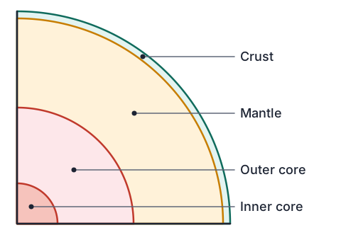
- Earth has a thin rocky crust, a thick mantle of hot rock, a liquid outer core and a solid inner core.
- The crust and the top, rigid part of the mantle together form the lithosphere, a stiff outer shell about 100 km thick.
- The lithosphere is cracked into large pieces called tectonic plates, like the shell of a cracked egg.
- Under the lithosphere is a hotter, softer layer of mantle that can flow very slowly, and the plates move over it.
- New Zealand sits across the boundary between two plates: the Australian Plate and the Pacific Plate.
| Layer | State | Rough thickness |
|---|---|---|
| Crust | Solid rock | 5 to 10 km under oceans, 30 to 70 km under continents |
| Mantle | Solid rock that flows very slowly | about 2900 km |
| Outer core | Liquid iron and nickel | about 2200 km |
| Inner core | Solid iron and nickel | about 1200 km radius |
Wegener and continental drift
- In 1912 the German scientist Alfred Wegener suggested that the continents had once been joined in one supercontinent, Pangaea, and had slowly drifted apart.
- His evidence came from several separate lines that all pointed the same way.
- Most geologists rejected the idea for decades, mainly because Wegener could not explain what force could push whole continents through solid rock.
- This is a normal part of science: a new idea is tested and argued over, and it needs a convincing mechanism as well as evidence.
| Evidence | What it shows |
|---|---|
| Coastlines fit | South America and Africa fit together like jigsaw pieces |
| Matching fossils | The land reptile Mesosaurus and the plant Glossopteris are found on continents now separated by oceans |
| Matching rocks | Rock layers and old mountain ranges line up across the Atlantic |
| Ancient ice | Scratches left by glaciers are found in places that are now tropical, such as India |
From drift to plate tectonics
- After the Second World War, ships mapped the ocean floor using sonar. Marie Tharp's maps revealed a huge mountain chain with a rift down its middle, the Mid-Atlantic Ridge.
- Rocks record Earth's magnetic field as they form. The seafloor showed matching magnetic stripes on each side of the ridges, in mirror image.
- Samples showed the seafloor is youngest at the ridges and older further away, so new crust is made at ridges and spreads outwards (Harry Hess, 1962).
- Deep ocean trenches and bands of earthquakes showed where old seafloor goes back down into the mantle.
- By the late 1960s these findings were combined into the theory of plate tectonics, which explained Wegener's evidence and gave the missing mechanism.
What moves the plates
- Earth's interior is very hot, partly from heat left over from its formation and partly from radioactive elements decaying in the rock.
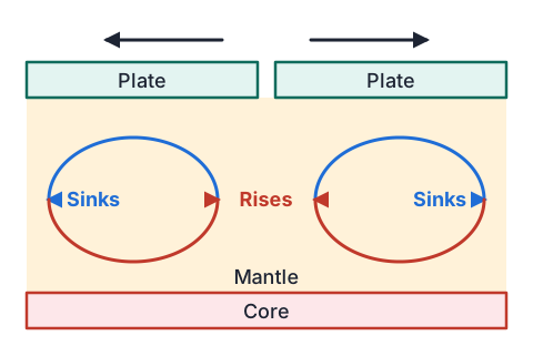
- Mantle rock near the core is heated, becomes slightly less dense and rises very slowly.
- Near the top it cools, becomes denser and sinks again, making a slow loop called a convection current.
- These currents drag on the plates above, moving them.
- Scientists now also think the cold, heavy edge of a plate sinking into the mantle helps pull the rest of the plate along.
Example: how fast does the Alpine Fault move?
- Rocks that were once side by side are now found about 480 km apart on opposite sides of the Alpine Fault, one in Nelson and one in Otago and Southland.
- Geologists estimate this movement took about 25 million years. Find the average rate in cm per year.
- 480 km = 480 000 m = 48 000 000 cmconvert to cm
- rate = 48 000 000 ÷ 25 000 000distance ÷ time
- rate ≈ 1.9 cm per yearabout as fast as fingernails grow
- tiny each year, but hundreds of km over millions of yearsslow processes add up
Three kinds of plate boundary
- Most earthquakes, volcanoes and new landforms happen where plates meet.
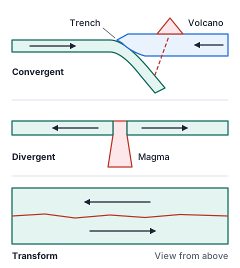
- At a convergent boundary plates push together. If one plate is ocean floor, it is usually forced down under the other (subduction), making a deep trench and a line of volcanoes. If both are continents, the crust crumples up into high mountains.
- At a divergent boundary plates move apart. Magma rises to fill the gap, making new crust, a mid-ocean ridge or a rift valley.
- At a transform boundary plates slide past each other sideways. Crust is neither made nor destroyed, but the plates catch and slip.
| Boundary | Movement | Features | Example |
|---|---|---|---|
| Convergent (subduction) | Together, one plate sinks | Trench, volcanoes, earthquakes | Hikurangi subduction zone, east of the North Island |
| Convergent (collision) | Together, both continental | High fold mountains | Himalayas |
| Divergent | Apart | Ridge or rift, new crust, volcanoes | Mid-Atlantic Ridge, Iceland, East African Rift |
| Transform | Sliding past | Long faults, earthquakes | Alpine Fault in the South Island, San Andreas Fault |
Example: following the plate boundary through New Zealand
- Trace the Australian and Pacific plate boundary from north of New Zealand to south of it, and name the type of boundary in each section.
- Kermadec Trench, north: Pacific Plate subductsconvergent; volcanic islands such as Raoul
- Hikurangi Trough, east of the North Island: Pacific Plate subducts under the North Islandconvergent; feeds the Taupō Volcanic Zone
- Alpine Fault, South Island: plates slide past and also push togethertransform, with squeezing that raises the Southern Alps
- Puysegur Trench, south-west of Fiordland: the Australian Plate subductsconvergent, but the other way round
- one boundary changes type along its length: subduction, then transform, then subduction again
Why earthquakes and volcanoes happen where they do
- Plates do not slide smoothly. Their edges lock together while the plates keep moving, so the rock bends and stress builds up.
- When the stress becomes greater than the rock's strength, it breaks and slips suddenly, releasing energy as an earthquake. This can happen at every type of boundary.
- At subduction zones, water carried down with the sinking plate helps the mantle above it melt, and the magma rises to form volcanoes.
- At divergent boundaries, rock rising from the mantle melts as the pressure on it drops.
- Some volcanoes are far from any boundary: hotspots sit above unusually hot mantle (Hawaii), and some intraplate fields form in the middle of a plate.
| Setting | Earthquakes | Volcanoes | Example |
|---|---|---|---|
| Convergent | Yes, including the largest | Yes | Taupō, Ruapehu, Whakaari |
| Divergent | Yes, mostly small and shallow | Yes | Iceland |
| Transform | Yes | Rarely | Alpine Fault |
| Hotspot | Some, linked to the volcano | Yes | Hawaii |
| Intraplate | Occasional | Sometimes | Auckland volcanic field |
Slow change and sudden events
- Some changes are too slow to notice in a lifetime: the Southern Alps rise by up to about 1 cm a year, while erosion wears them down almost as fast.
- Other changes happen in seconds or days, but they are caused by the same slow plate movement building up stress.
- Over millions of years, steady movement of a few centimetres a year opens oceans and builds mountain ranges.
- Knowing both timescales helps planners: the Alpine Fault has broken in large earthquakes every few hundred years, and its last big rupture was in 1717.
| Event | Type | Timescale |
|---|---|---|
| Southern Alps uplift | Gradual | Millions of years |
| Taupō eruption, about 1800 years ago | Sudden | Days to weeks |
| Rangitoto forming, about 600 years ago | Sudden | Years of eruptions |
| Wairarapa earthquake 1855, magnitude about 8.2 | Sudden | Seconds to minutes; raised the Wellington coast |
| Kaikōura earthquake 2016, magnitude 7.8 | Sudden | About 2 minutes; lifted parts of the coast by several metres |
Example: reading earthquake depth data
- GeoNet records every earthquake in New Zealand. These are ten years of its records for a strip of the central North Island, from the Hawke's Bay coast west to Taumarunui.
- Shallow earthquakes happen everywhere, so the table gives how deep the deepest earthquakes go under each place.
- What does the pattern show, and how does it link to the volcanoes?
| Place (east to west) | Deepest earthquakes reach about (km) |
|---|---|
| Offshore, east of Hawke's Bay | 33 |
| Napier | 39 |
| Taupō | 94 |
| Ruapehu | 157 |
| Taumarunui | 214 |
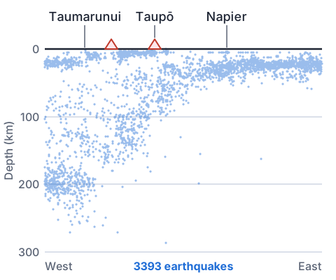
- depth increases steadily going west, from 33 km to 214 kmread down the table
- earthquakes happen in the cold, brittle plate as it sinksthey mark where the plate is
- so the Pacific Plate dips westward under the North Islanda sloping line of quakes
- the volcanoes of Taupō and Ruapehu sit above the plate where it is about 100 to 150 km downTaupō 94 km, Ruapehu 157 km
- a subducting plate under the North Island, with volcanoes above its deeper part
Patterns on a world map: the Ring of Fire
- Plot every large earthquake and active volcano on a world map and they are not scattered randomly. They form narrow belts.
- The biggest belt circles the Pacific Ocean, from New Zealand to Japan, Alaska and down the Andes. It is called the Pacific Ring of Fire.
- Around 90% of the world's earthquakes and about three quarters of its active volcanoes are on this ring.
- The belts trace the edges of the plates, which is one of the strongest pieces of evidence for plate tectonics.
- Quieter belts follow the mid-ocean ridges, and the Himalayas form a band of earthquakes with almost no volcanoes, which fits a continent to continent collision.
Modelling plate boundaries
- Simple models make slow boundary processes visible on a desk.
- Each model shows one idea well but leaves things out, so say what it gets right and what it misses.
| Model | Boundary | What it shows | What it misses |
|---|---|---|---|
| Push two towels together on a table | Convergent (collision) | Crust folding up into mountains | Rock breaks as well as folds, over millions of years |
| Slide one book under another | Convergent (subduction) | One plate sinking under another | No melting or volcanoes |
| Pull two pieces of a sliced chocolate bar apart | Divergent | A gap opening as the plates separate | No magma filling the gap |
| Rub two sandpaper blocks past each other | Transform | Sticking, then a sudden jerk, like an earthquake | Real faults are kilometres deep |
Common mistakes
- The plates float on a layer of liquid magma.The mantle under the plates is solid rock that flows very slowly; the only liquid layer is the outer core, far deeper.
- The Alpine Fault is a subduction zone, like the one under the North Island.The Alpine Fault is mainly a transform boundary where the plates slide past each other, which is why it has big earthquakes but no volcanoes.
- Volcanoes and earthquakes happen at every type of boundary.Earthquakes happen at all three, but volcanoes form where plates collide by subduction or move apart, and hardly ever at transform boundaries.
- 480 km is 480 000 cm.1 km is 1000 m and 1 m is 100 cm, so 1 km is 100 000 cm and 480 km is 48 000 000 cm.
Stick and slip: a fault in a rubber band
You need: 2 or 3 heavy books, a long rubber band, sticky tape, a bath towel, a ruler
- Lay the towel flat on the table and stack the books on it.
- Tape one end of the rubber band firmly to the front edge of the bottom book, and lay the ruler beside the stack to mark where it starts.
- Hold the free end of the band and pull it along the table very slowly, keeping your hand moving at the same steady speed the whole time.
- Keep pulling for several jumps, noting how far the band stretches before each one and how far the books move.
- Look for: the books stay stuck while the band stretches, then suddenly lurch forward and stick again, even though your pull never changed; locked plate edges store stress and release it in sudden earthquakes in the same way.
Safety: A stretched rubber band can snap or slip off and flick hard, so do not overstretch it and keep your face back from it.
Your turn
- 1. A plate moves 5 cm a year. How far does it move in 2 million years? Give your answer in km.
- 2. What type of boundary is the Alpine Fault mainly, and what mountain range has formed along it?
- 3. Why are there active volcanoes in the central North Island but not along the Alpine Fault?
- 4. Give the main reason most scientists rejected Wegener's continental drift at first, and what later evidence changed their minds.
- 5. A map shows a long line of earthquakes in the middle of the Atlantic Ocean, mostly shallow, with some volcanoes. What type of boundary is this, and why?
Show answer
1. 5 × 2 000 000 = 10 000 000 cm = 100 000 m = 100 km. 2. Transform (with some pushing together); the Southern Alps. 3. Under the central North Island the Pacific Plate is subducting, and water from it helps the mantle melt to make magma; the Alpine Fault is mostly plates sliding past each other with no plate sinking beneath, so little magma forms. 4. He could not explain what force moved the continents; seafloor mapping, mirror-image magnetic stripes and young rock at mid-ocean ridges showed seafloor spreading, giving a mechanism. 5. Divergent (the Mid-Atlantic Ridge): plates are moving apart, magma rises to make new crust, and the quakes are shallow because the lithosphere there is thin and hot.
Recap
- The lithosphere (crust plus rigid upper mantle) is broken into plates that move a few centimetres a year.
- Wegener proposed continental drift; seafloor evidence turned it into plate tectonics.
- Mantle convection, powered by Earth's internal heat, drives the plates.
- Earthquakes happen at all boundaries; volcanoes at convergent and divergent boundaries, hotspots and some intraplate sites.
- New Zealand straddles the Australian and Pacific plates, with subduction in the north and east and the Alpine Fault in the south.
| Boundary | Movement | NZ or world example |
|---|---|---|
| Convergent | Together | Hikurangi subduction zone, Himalayas |
| Divergent | Apart | Mid-Atlantic Ridge |
| Transform | Sliding past | Alpine Fault |
How is Year 10 maths going?
See the Year 10 maths guide