Geological processes at Franz Josef and the Southern Alps
What this lesson covers
- The three rock types and the rock cycle processes that make and change them.
- The Alpine Fault: how the Pacific and Australian plates meet at Franz Josef / Waiau, and how fast the land moves.
- Greywacke (sedimentary) and schist (metamorphic): how each formed and why schist is found next to the fault.
- Erosion that shapes the landforms: glaciers, rivers, rain, freeze and thaw, and landslides.
- Sequencing events in a landscape with superposition and cross-cutting.
- Linking plate tectonics, the rock cycle and erosion for Merit and Excellence.
What the investigation must show
- AS 91189 is an internal: you investigate one named place in New Zealand (anywhere on the Zealandia continent counts) and report on its geology.
- Name the rock types found there (igneous, sedimentary or metamorphic; exact rock names help but are not required).
- Describe how plate movement and the rock cycle made those rocks, and how erosion shaped the landforms you can see today.
- Merit explains these processes (how and why they happen) rather than only describing them.
- Excellence discusses the links: how plate tectonics drives the rock cycle in this place, and how the erosion matches the shape of today's landforms.
- It must be about your place, not general geology: saying how schist forms in general is not enough; you say how the schist at Franz Josef formed.
Rock types and the rock cycle
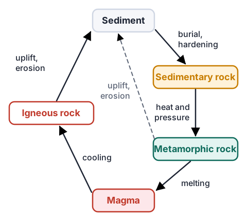
- Igneous rock forms when magma or lava cools and crystallises, such as granite deep underground or basalt from a volcano.
- Sedimentary rock forms when sediment (gravel, sand, mud, shells) is deposited in layers, buried, squeezed and cemented, such as greywacke and limestone.
- Metamorphic rock forms when any rock is buried deep enough that heat and pressure change its minerals and texture without melting it, such as schist and marble.
- Uplift brings rocks to the surface, where weathering breaks them down and erosion carries the pieces away to be deposited as new sediment.
- Plate tectonics drives the cycle: plates colliding bury rocks deep, heat them and push them back up.
The locality: a town on a plate boundary
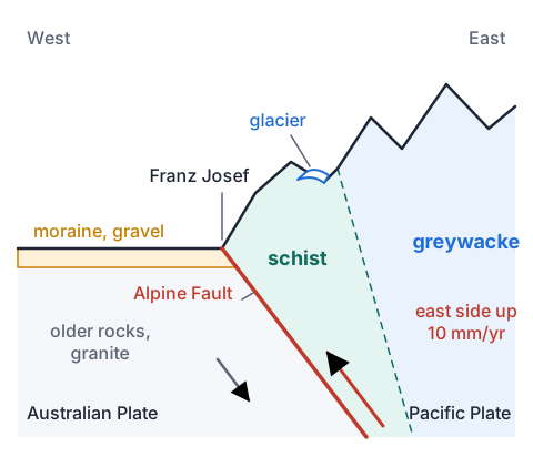
- Franz Josef / Waiau, in South Westland, sits where the Pacific Plate and the Australian Plate meet along the Alpine Fault. The fault crosses the town, and GNS Science has mapped its scarp across State Highway 6 and Condon Street.
- The plates slide past each other sideways, and the Pacific side (east of the fault) is also pushed up over the Australian side.
- Rocks on the two sides have been carried about 480 km apart over millions of years, so the rock type changes suddenly across the fault.
- East of the fault, schist forms the steep range front and greywacke the higher mountains towards Aoraki/Mt Cook. West of the fault, the lowland is covered by glacial moraine and river gravels.
| Alpine Fault near Franz Josef | Rate or size |
|---|---|
| Sideways slip (the east side moves south relative to the west) | About 25 mm a year |
| Reverse slip (east side up) | About 10 mm a year |
Greywacke: sedimentary rock from Gondwana
- Greywacke is a hard grey sandstone with thin bands of mudstone. Much of the Southern Alps is made of it, and it is New Zealand's most common rock.
- It began as sand and mud washed off the edge of Gondwana. Underwater avalanches of muddy water (turbidity currents) spread sand over the sea floor, and fine mud settled on top between them, building up thousands of metres of layers.
- Burial compacted and cemented the layers into rock: that is the rock cycle's sedimentary step.
- Plate collision later tilted these layers, which is why greywacke beds in the Alps are often turned on end.
| Greywacke in the Southern Alps | Value |
|---|---|
| Age of the greywacke | About 200 to 240 million years |
| Sideways offset of rocks across the Alpine Fault | About 480 km |
| Boulders in West Coast rivers | Mostly greywacke, some schist |
Schist: buried, heated and pushed back up
- Schist is a shiny metamorphic rock with thin, wavy layers of flat minerals such as mica.
- Near the Alpine Fault, greywacke was dragged many kilometres deep, where the heat and pressure recrystallised it into schist: the rock cycle's metamorphic step.
- The fault then lifts the east side up by about 10 mm a year. Uplift is greatest beside the fault, so the deepest rock, schist, is brought to the surface there, while greywacke from shallower depths makes the mountains further east.
- Te Ara reports that the rock now at the summit of Aoraki/Mt Cook was below sea level less than a million years ago.
- So one plate process does two jobs at Franz Josef: it buries greywacke to make schist, and it pushes that schist back up to where we can see it.
| Uplift of the Southern Alps | Value |
|---|---|
| Uplift east of the Alpine Fault, last 10,000 years | 10 mm or more a year |
| Total uplift near Aoraki/Mt Cook, last 2 to 3 million years | Up to 20,000 m |
| Uplift on the west side of the Alps further from the fault | About 5 mm a year |
Erosion: what shapes the landforms
- Glaciers: in the ice ages, glaciers filled the valleys and flowed past today's coast. Ice dragging rock along its base ground the valleys into U-shapes, and Kā Roimata o Hine Hukatere / Franz Josef Glacier still carves its valley today.
- Moraines: glaciers dump the rock they carry in ridges, and on the West Coast these moraines are hundreds of metres high.
- Rain and rivers: westerly winds rise over the Alps and drop huge rainfall, so rivers such as the Waiho carry greywacke and schist gravel to the sea.
- Freeze and thaw: water in cracks freezes, expands and splits rock, and rock already cracked by uplift breaks easily, building scree slopes.
- Landslides: in December 1991 a rock avalanche of about 14 million cubic metres fell from Aoraki/Mt Cook.
- Erosion has kept pace with uplift, so the Alps stay at roughly the same height even though the rock keeps rising.
| Erosion in the Southern Alps | Value |
|---|---|
| Rainfall on the western side, south of Hokitika | More than 10,000 mm a year |
| Aoraki/Mt Cook rock avalanche, December 1991 | About 14 million m³ |
| Ice-age glaciers over the Alps | Up to 1,000 m thick |
Sequencing the events
- Superposition: in undisturbed layers, the bottom layer was laid down first, so it is the oldest.
- Cross-cutting: a fault or an igneous intrusion is younger than every rock it cuts through.
- Erosion surfaces: a layer lying on an eroded surface is younger than the erosion and everything below it.
- At Franz Josef the order is: sand and mud deposited off Gondwana; buried and hardened into greywacke; the Alpine Fault forms as the plate boundary; collision buries greywacke and turns it into schist; uplift raises the Alps; glaciers carve the valleys and leave moraines; rivers and rain keep eroding and depositing gravel today.
| Event | When |
|---|---|
| Greywacke sediment laid down off Gondwana | From about 300 million years ago, over about 200 million years |
| Plate boundary through Zealandia begins to form | About 25 million years ago |
| Major mountain building | Since about 5 million years ago |
| Most recent glaciation at its largest | About 18,000 years ago |
Example: one section at each grade
- Achieved names the rock type and describes the process.
- Merit explains how and why the process happens at this place.
- Excellence discusses how the plate process and the rock cycle connect here, and how that ties to the erosion and the landforms.
| Grade | What the student wrote |
|---|---|
| Achieved | The hills behind Franz Josef are schist, a metamorphic rock. It formed from greywacke that was heated and squeezed underground. The valley was eroded by the Franz Josef Glacier. |
| Merit | At Franz Josef the Pacific Plate is pushed up over the Australian Plate along the Alpine Fault. Greywacke on the Pacific side was carried deep down, where heat and pressure recrystallised its minerals into layered schist. The east side rises about 10 mm a year, so this deep rock is now at the surface. The glacier drags rock along its base, grinding the valley into a U-shape. |
| Excellence | The Alpine Fault links both stories. Collision buried greywacke deep enough to become schist, and the same reverse movement, about 10 mm a year, lifts it fastest beside the fault, which is why schist forms the range front and greywacke the peaks further east. That uplift also builds mountains high enough to force westerly air up, giving over 10,000 mm of rain a year in places and the snow that feeds the glacier. Glaciers, rivers and landslides wear the rock away about as fast as it rises, so the Alps keep their height while the valleys deepen, and the gravel they carry to the coast is the start of the next sedimentary rock. |
Common mistakes
- Schist is igneous because it formed with heat.Schist never melted: heat and pressure changed solid greywacke, so it is metamorphic.
- The Alps are tall because plates push them up, and that is the whole story.Erosion matters too: the Alps rise about 10 mm a year but erosion removes rock nearly as fast, so their height stays about the same.
- My report explains how schist forms anywhere in the world.Tie each process to your place: which plates, which fault, which rocks and which landforms are there.
- The top layer is the oldest because it has been there longest.In undisturbed layers the bottom layer was deposited first, so it is the oldest.
Squeeze layers into folds and faults
You need: a clear plastic container about 30 cm long, flour, cocoa powder, a ruler, a flat piece of stiff card that fits across the container, a spoon
- Spoon a 1 cm layer of flour into the container and smooth it flat with the ruler, then sift a thin layer of cocoa on top.
- Repeat until you have four flour layers separated by cocoa lines, like sedimentary beds.
- Stand the card upright at one end and push it slowly and steadily along the container, about 10 cm.
- Look through the side at the layers, and sketch what happened to them.
- Look for: the layers bend into folds and then break along sloping cracks where one block rides up over another. That is how plate collision tilts and faults greywacke and pushes rock up along faults such as the Alpine Fault.
Safety: Raw flour can carry E. coli, so do not eat any of it, push slowly so no dust goes up your nose, and wash your hands afterwards.
Your turn
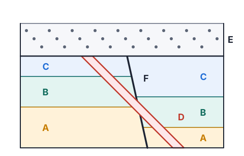
In the cross-section, which of layers A, B and C is the oldest?
Is fault F older or younger than layer C?
Put A, B, C, D, E and F in order from oldest to youngest.
What rock type is schist, and which process made it at Franz Josef?
Why are most boulders in West Coast rivers greywacke, with less schist?
Write one sentence linking uplift and erosion in the Southern Alps, as an Excellence answer would.
Show answer
1. A, because it is at the bottom of undisturbed layers. 2. Younger: F cuts through C, so C was there first. 3. A, B, C, F, D, E: the layers by superposition, then the fault that cuts them, then the dyke that cuts the fault, then erosion and gravel E on top. 4. Metamorphic; greywacke was buried deep by plate collision on the Alpine Fault and changed by heat and pressure. 5. Most of the Alps are greywacke and schist is only a narrow band beside the fault, so rivers carry mostly greywacke. 6. For example: the Alpine Fault lifts the Alps about 10 mm a year, and because heavy rain, glaciers and landslides remove rock about as fast, the mountains stay roughly the same height while their valleys are cut deeper.
Recap
- Identify the rock types at your place and say how each formed there.
- At Franz Josef the Alpine Fault buried greywacke to make schist and lifts it back up about 10 mm a year.
- Glaciers, rivers, rain, frost and landslides shape the landforms, removing rock about as fast as it rises.
- Sequence events with superposition and cross-cutting, and for Excellence link plate tectonics, the rock cycle and erosion.
| Rock or landform | Type or process | Plate link |
|---|---|---|
| Greywacke | Sedimentary | Tilted and lifted by collision |
| Schist | Metamorphic | Buried, heated and lifted on the Alpine Fault |
| U-shaped valley | Glacial erosion | Uplift makes the high snowfields |
| Moraine and river gravel | Deposition | Eroded from rising mountains |
How is NCEA Level 2 maths going?
See the NCEA Level 2 maths guide