Heat transfer in the Earth system
What this lesson covers
- Conduction, convection and radiation, and where each happens in the Earth system.
- Shortwave radiation from the Sun and longwave radiation from Earth, and how each is transmitted, reflected, absorbed or scattered.
- Why the sky is blue and sunsets are red, and how clouds and greenhouse gases change surface temperature.
- Specific heat capacity: why the sea warms and cools slowly, and how that gives coasts milder climates and sea breezes.
- Global circulation, and how latent heat carries energy from the sea surface into storms.
Three ways heat moves
- Conduction passes heat through a material by collisions: fast-vibrating particles bump their neighbours and pass on kinetic energy. It works best in solids, and it is how warm ground heats the thin layer of air touching it.
- Convection carries heat by moving the fluid itself: heated fluid expands, becomes less dense and rises, and cooler, denser fluid takes its place.
- Radiation is energy carried by electromagnetic waves, so it needs no particles at all; it is the only way energy crosses space from the Sun to Earth.
- Heat always flows from hotter to colder, and everything radiates: the hotter an object, the more it radiates, and the shorter its wavelengths.
| Process | How it works | In the Earth system |
|---|---|---|
| Conduction | particle collisions | warm sea heating the air touching it |
| Convection | a fluid moving because of a density difference | thunderclouds, sea breezes, the mantle |
| Radiation | electromagnetic waves, no medium needed | sunlight warming the ground; the ground losing infrared at night |
Shortwave in, longwave out
- The Sun is extremely hot, so it radiates mostly shortwave radiation: ultraviolet, visible light and near infrared.
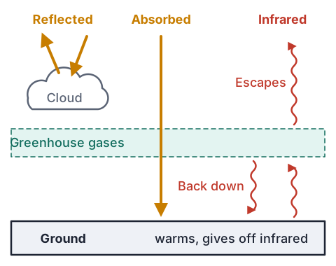
- On the way down, some is reflected by clouds, ice and pale surfaces, some is scattered by gas molecules, much of the ultraviolet is absorbed by ozone, and the rest is transmitted to the ground and absorbed, warming it.
- Albedo is the fraction of radiation a surface reflects: fresh snow and thick low cloud have a high albedo, while dark sea and forest have a low albedo and absorb most of what reaches them.
- Earth's surface is far cooler than the Sun, so it radiates longwave infrared, by day and by night.
- Much of that infrared is absorbed by greenhouse gases and clouds, which re-emit it in all directions, some of it back down to the surface.
Blue skies, red sunsets and white clouds
- Visible light is a mix of colours: red has the longest wavelength, lowest frequency and lowest energy; blue and violet have the shortest wavelength, highest frequency and highest energy.
- Nitrogen and oxygen molecules are far smaller than a wavelength of light, and they scatter short wavelengths much more strongly than long ones (Rayleigh scattering), so blue light is sent all over the sky and reaches your eyes from every direction.
- Near sunrise and sunset, light takes a much longer path through the air, so most of the blue is scattered out before it arrives, leaving the orange and red that are transmitted.
- Smoke, dust and volcanic ash add extra scattering, so the low Sun, or a rising Moon, can look deep red.
- Cloud droplets are bigger than every visible wavelength and scatter all colours about equally, so clouds look white; a thick cloud looks grey from below because little light gets through it.
Greenhouse gases and clouds
- Greenhouse gases such as water vapour, carbon dioxide and methane let most shortwave sunlight through, but they absorb the longwave infrared coming up from the surface.
- They then re-emit it in all directions, including back down, so the lower atmosphere and the surface stay warmer than they otherwise would; they absorb and re-emit, they do not reflect.
- Low, thick cloud has a high albedo, so by day it reflects much of the incoming sunlight and keeps the surface cooler; at night it absorbs and re-emits outgoing infrared, so cloudy nights stay warmer than clear ones.
- High, thin cloud lets most sunlight through but still absorbs outgoing infrared, so overall it tends to warm the surface.
- Adding more greenhouse gas strengthens the greenhouse effect, which is why the climate is warming.
Specific heat capacity: why the sea is slow
- Specific heat capacity, c, is the energy needed to warm 1 kg of a substance by 1 °C, so the energy needed is Q = mcΔT.
- Water's is about 4200 J kg⁻¹ °C⁻¹, roughly five times that of dry sand or rock (about 800), so the same energy warms dry land about five times as much as the same mass of water.
- The sea is slow for other reasons too: sunlight reaches metres down into the water, waves and currents mix the heat through a deep layer, and evaporation uses some of the energy.
- On land, the energy is absorbed in a thin top layer, and soil conducts heat poorly, so the surface heats quickly by day and cools quickly at night.
- So the sea changes temperature slowly, day to night and summer to winter, and places beside it have milder climates.
Example: the same energy, two temperature rises
- Sunlight delivers 42 000 J to 1.0 kg of water and 42 000 J to 1.0 kg of dry sand.
- Take c = 4200 J kg⁻¹ °C⁻¹ for water and 800 J kg⁻¹ °C⁻¹ for dry sand. Find each temperature rise.
- ΔT = Q ÷ (mc)rearrange Q = mcΔT
- water: ΔT = 42 000 ÷ (1.0 × 4200) = 10 °C
- sand: ΔT = 42 000 ÷ (1.0 × 800) = 52.5 °C
- the sand warms 52.5 °C, the water only 10 °C
- 52.5 ÷ 10 = 5.25, the same as 4200 ÷ 800the temperature rise is inversely proportional to c
Example: inland Alexandra and coastal Dunedin
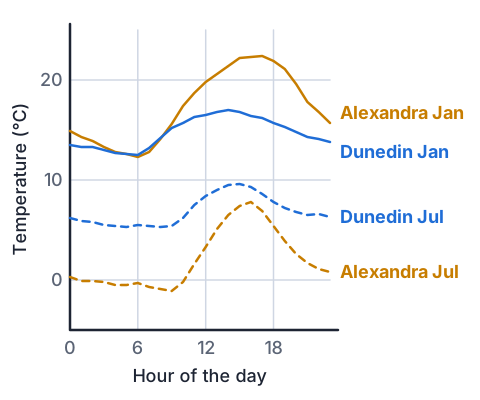
- NIWA's figures for Alexandra, inland in Central Otago, and Dunedin, on the coast, are below.
- Work out each place's daily range in January and in July, and explain the difference.
| Place | January coldest | January warmest | July coldest | July warmest |
|---|---|---|---|---|
| Alexandra | 12.3 | 22.4 | −1.1 | 7.8 |
| Dunedin | 12.5 | 17.0 | 5.3 | 9.6 |
- Alexandra, January: 22.4 − 12.3 = 10.1 °C
- Dunedin, January: 17.0 − 12.5 = 4.5 °C
- Alexandra, July: 7.8 − (−1.1) = 8.9 °Csubtracting a negative adds
- Dunedin, July: 9.6 − 5.3 = 4.3 °C
- Alexandra's daily range is about twice Dunedin's in both months
- inland, the land heats fast by day and cools fast at night; Dunedin's air comes off a sea whose high heat capacity keeps it at a steady temperature
Sea breezes and land breezes
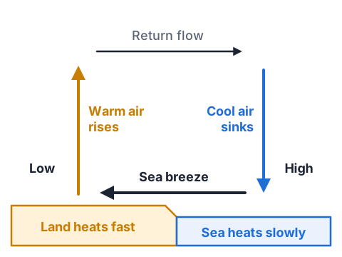
- On a sunny day the land heats faster than the sea, because of its lower heat capacity.
- Air over the land is heated by conduction from the ground, expands, becomes less dense and rises, lowering the pressure at the surface over the land.
- Air over the cooler sea is denser and at a higher pressure, so it flows onshore to replace the rising air: a sea breeze.
- Higher up, the air flows back out over the sea, cools and sinks, which closes the convection loop.
- At night the land cools faster than the sea, so the loop runs the other way and a gentler land breeze blows out to sea.
Global circulation: moving heat toward the poles
- Near the equator the Sun is high, so each square metre receives far more energy than near the poles, where the same sunlight arrives at a low angle and is spread over a bigger area.
- Hot air rises at the equator, giving low pressure, towering clouds and heavy rain; high up it spreads toward the poles, cools and sinks at about 30° north and south, giving belts of high pressure and dry deserts. This loop is the Hadley cell.
- Two more cells sit closer to each pole, so in each hemisphere the atmosphere carries heat from the tropics toward the pole in three loops.
- Earth's spin turns the surface winds, so between about 30° and 60° south they blow from the west: the westerlies that sweep across Aotearoa and drop heavy rain on the West Coast.
- Ocean currents carry heat toward the poles as well, so the tropics do not keep getting hotter, nor the poles colder.
Latent heat: the energy hidden in water vapour
- Latent heat is energy absorbed or released when a substance changes state, with no change in its temperature.
- When water evaporates from the sea, it absorbs latent heat from the surface water, cooling the sea, and the vapour carries that energy up into the atmosphere.
- When the vapour condenses in a rising cloud, the same latent heat is released, warming the air in the cloud so it stays less dense than the air around it and keeps rising.
- That is what powers towering thunderclouds and tropical cyclones: warm seas supply plenty of vapour, and its latent heat drives the storm.
- Evaporation, convection and condensation together move more heat from Earth's surface into the atmosphere than conduction from the ground does.
Example: what each grade looks like
- Achieved describes the right physics in correct terms; Merit explains the cause and effect; Excellence links several principles into one chain and ties it to the place in the question.
- An annotated diagram counts as evidence, so a labelled convection loop strengthens any of these answers.
| Grade | A model answer |
|---|---|
| Achieved | The land heats up faster than the sea, so the air over the land rises and cooler air from the sea moves in. |
| Merit | Land has a lower heat capacity than water, so the same sunlight raises its temperature more. The air above is heated by conduction, expands, becomes less dense and rises, and denser air from over the sea flows in to replace it. |
| Excellence | The land and sea absorb similar sunlight, but water's heat capacity is about five times higher and its heat is mixed through a deep layer, so the land's surface warms far faster. The ground heats the air above it by conduction; that air expands, its density falls and it rises, lowering the surface pressure over the land. Cooler, denser air at higher pressure over the sea flows onshore as the sea breeze, while the risen air returns seaward high up, cools and sinks, completing a convection current. |
Common mistakes
- Water has a high heat capacity, so it heats up quickly.A high heat capacity means it takes more energy for each degree, so water heats up, and cools down, slowly.
- Greenhouse gases reflect heat back down to Earth.They absorb outgoing longwave infrared and re-emit it in all directions, some of it back toward the surface.
- The sky is blue because it reflects the colour of the sea.Air molecules scatter short blue wavelengths far more than long red ones, so blue light reaches you from all over the sky.
- Sunsets are red because the Sun cools down in the evening.At sunset the light's path through the air is much longer, so the blue is scattered out and mainly red and orange are transmitted.
Sun on soil and water
You need: two identical plastic containers, dry sand or dry garden soil, tap water, a cooking thermometer, a sunny spot outside or on a windowsill, a timer
- Fill one container with water and the other with dry sand or soil to the same depth, and leave both indoors for 30 minutes so they start at the same temperature.
- Measure the temperature just under the surface of each, then put both in full sun, side by side.
- After 30 minutes, measure each again at the same depth.
- Move both into the shade, wait 20 minutes, and measure a third time.
- Look for: the sand or soil warms much more in the sun and loses more of that warmth in the shade, because water's heat capacity is about five times higher.
Safety: A cooking thermometer has a sharp metal probe, so point it away from you and keep it away from younger children; and dark soil in hot sun can burn, so test it with a quick fingertip first.
Your turn
How much energy warms 2.0 kg of water by 3.0 °C? Use c = 4200 J kg⁻¹ °C⁻¹.
8400 J is absorbed by 0.50 kg of dry sand (c = 800 J kg⁻¹ °C⁻¹). Find its temperature rise.
Using NIWA's table, how much bigger is Alexandra's July daily range than Dunedin's?
Explain why a cloudy winter night is usually warmer than a clear one.
Explain why the sky is blue.
Which way does the breeze blow on a beach on a clear night, and why?
Show answer
1. Q = mcΔT = 2.0 × 4200 × 3.0 = 25 200 J. 2. ΔT = Q ÷ (mc) = 8400 ÷ (0.50 × 800) = 21 °C. 3. 8.9 − 4.3 = 4.6 °C bigger. 4. The cloud absorbs the longwave infrared the ground gives off and re-emits some of it back down, so less heat escapes to space. 5. Gas molecules scatter short blue wavelengths far more than long red ones, so scattered blue light reaches your eyes from all over the sky. 6. From the land out to sea: the land cools faster than the sea, so air over the sea is warmer and rises, and denser air from over the land flows out to replace it.
Exam-style question: the Canterbury nor'wester
- Moist westerly air from the Tasman Sea is forced up over the Southern Alps. The West Coast gets heavy rain, while the Canterbury Plains, on the other side, get a hot, dry nor'wester.
Describe what latent heat is.
Explain why the air cools as it rises over the Alps, and why rain falls on the West Coast.
Discuss why the air reaching the Canterbury Plains is warmer and drier than it was at the same height over the Tasman Sea.
Show answer
1. Achieved: the energy absorbed or released when a substance changes state without changing temperature; evaporation absorbs it and condensation releases it. 2. Merit: as the air rises, the pressure on it falls, so it expands and cools. Once it has cooled enough, its water vapour condenses into cloud droplets, which grow and fall as rain on the western side of the ranges. 3. Excellence: condensation releases latent heat into the rising air, so above the cloud base it cools more slowly than dry air would. The water falls out as rain on the West Coast, so the air that crosses the main divide has lost much of its moisture. As it descends on the eastern side, the rising pressure compresses it and it warms at the faster rate of dry air all the way down. It therefore reaches the plains warmer than it was at the same height on the western side, and drier, because its water stayed behind as rain while the latent heat that water carried stayed in the air. This is the föhn effect. Describing latent heat earns Achieved; explaining the cooling and condensation earns Merit; linking latent heat release, the loss of water and warming by compression earns Excellence.
Greenhouse Effect
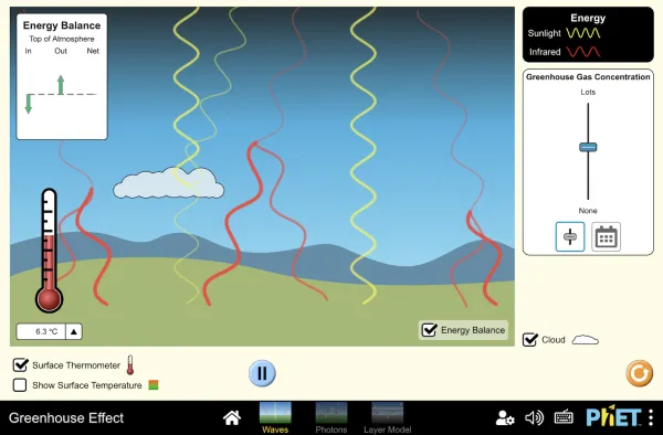
Full screen · PhET Interactive Simulations, University of Colorado Boulder, CC BY 4.0
Recap
- Conduction is particle collisions, convection is a fluid moving because of a density difference, and radiation is electromagnetic waves.
- The Sun sends shortwave radiation; Earth gives off longwave infrared, which greenhouse gases and clouds absorb and re-emit.
- Short blue wavelengths scatter most, so the sky is blue; a long path through the air leaves red sunsets.
- Water's high heat capacity keeps coasts mild and drives sea breezes by day and land breezes by night.
- Latent heat taken up by evaporation is released by condensation, which powers storms and warms föhn winds.
| Principle | Use it to explain |
|---|---|
| Scattering of short wavelengths | blue sky, red sunsets, red moonrise |
| Albedo | snow, ice and low cloud keeping places cool |
| Absorption and re-emission of infrared | the greenhouse effect, warm cloudy nights |
| Specific heat capacity | mild coasts, sea and land breezes |
| Latent heat | storms, cyclones, the nor'wester |
How is NCEA Level 2 maths going?
See the NCEA Level 2 maths guide