Ocean heat, tides, waves and El Niño
What this lesson covers
- Why the ocean stores so much heat, and how currents carry it towards the poles.
- How the ocean moderates New Zealand's climate, including marine heatwaves.
- Waves as energy transfer: orbital motion, wave speed in deep and shallow water, and breaking.
- Tides as energy transfer: the Moon and Sun, spring and neap tides, and New Zealand's tides.
- El Niño and La Niña: trade winds, the Walker circulation, the thermocline and upwelling.
- How ENSO changes New Zealand's winds, rainfall and temperatures.
The ocean as a heat store
- Seawater has a specific heat capacity of about 3990 J kg⁻¹ K⁻¹, four times that of air (about 1005 J kg⁻¹ K⁻¹), and the ocean has about 270 times the mass of the atmosphere.
- So the ocean warms and cools slowly and stores enormous amounts of energy: it has taken up about 90% of the extra heat trapped by greenhouse gases since the 1970s.
- Water also absorbs a lot of energy when it evaporates (latent heat), which is released into the atmosphere when the vapour condenses into cloud, often far away.
Try it: land and sea heat differently
Example: how deep is one atmosphere of heat?
- The atmosphere has a mass of 5.1 × 10¹⁸ kg. The ocean covers 3.6 × 10¹⁴ m², with density 1025 kg m⁻³.
- How deep a layer of ocean needs the same energy as the whole atmosphere to warm by 1 °C?
- atmosphere: mc = 5.1 × 10¹⁸ × 1005 = 5.13 × 10²¹ J per °CQ = mcΔT with ΔT = 1 °C
- ocean, per metre of depth: mass = 3.6 × 10¹⁴ × 1 × 1025 = 3.69 × 10¹⁷ kg
- mc per metre = 3.69 × 10¹⁷ × 3990 = 1.47 × 10²¹ J per °C
- depth = 5.13 × 10²¹ ÷ 1.47 × 10²¹ = 3.5 m
- the ocean averages about 3700 m deep, so it holds about 1000 times as much
- the top 3.5 m of the ocean
Moving heat towards the poles
- The tropics receive more solar energy than they radiate away and the poles less, so the ocean and atmosphere carry heat polewards; the ocean carries most of it in the tropics and the atmosphere most of it at higher latitudes.
- Warm western boundary currents, such as the East Australian Current, carry tropical water south; part of it crosses the Tasman Sea and flows past northern New Zealand as the East Auckland Current.
- Deep, cold water returns towards the equator in the thermohaline circulation, completing the loop.
- Because the sea warms and cools slowly, coastal places have smaller temperature ranges than inland ones: Hokitika's summers and winters are much closer in temperature than Alexandra's.
- When ocean heat builds up, marine heatwaves follow: in the summers of 2017 to 2018 and 2021 to 2022, seas around New Zealand ran several degrees above normal, stressing kelp, fish and shellfish.
Waves carry energy, not water
- Wind transfers energy to the sea surface. The size of the waves depends on wind speed, how long it blows and the fetch (the distance of open water it blows over), which is why the Southern Ocean's westerlies make big swells.
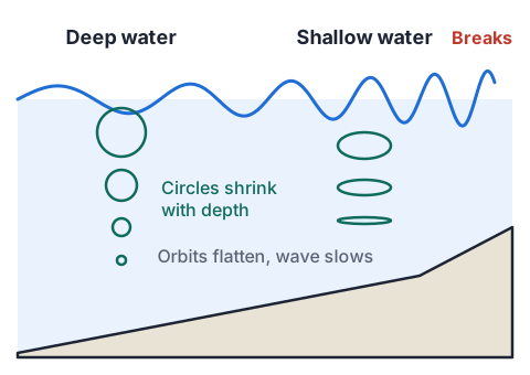
- As a wave passes, each water particle moves in a near-circle and returns almost to where it started; the energy travels on, not the water. The circles shrink with depth and almost vanish below half a wavelength.
- In deep water a wave's speed depends on its period: v = gT ÷ 2π, so long-period swell outruns short wind chop and arrives first at the coast.
- In water shallower than about a twentieth of a wavelength, speed depends only on depth: v = √(gd). As a wave reaches the shore it slows, its wavelength shortens, its height grows, and it breaks.
- A wave's energy is proportional to its height squared, so doubling the height means four times the energy.
Try it: waves carry energy
Example: a Southern Ocean swell reaches Raglan
- A swell with a period of 12 s crosses the deep Tasman Sea and reaches the shallow water at Raglan.
- Find its speed and wavelength in deep water, and its speed where the water is 3.0 m deep. Use g = 9.8 m s⁻².
- deep water: v = gT ÷ 2π = 9.8 × 12 ÷ 6.283 = 18.7 m s⁻¹
- λ = vT = 18.7 × 12 = 225 m
- shallow water: v = √(gd) = √(9.8 × 3.0) = √29.4 = 5.4 m s⁻¹
- the period stays 12 s, so λ = 5.4 × 12 = 65 m: the wave bunches up
- 18.7 m s⁻¹ and 225 m offshore; 5.4 m s⁻¹ in 3.0 m of water
Tides: energy from the Moon and Sun
- The Moon's gravity pulls hardest on the side of the Earth facing it and least on the far side, stretching the ocean into two bulges; as the Earth turns, most coasts get two high tides about every 24 h 50 min.
- The Sun does the same, about half as strongly. When Sun, Moon and Earth line up (new and full Moon) the effects add: spring tides with the biggest range; at the quarter Moons they partly cancel: neap tides.
- Around New Zealand the main tide travels as a wave anticlockwise round the country, taking about 12 hours to go round, so high tide comes at different times along the coast; across Cook Strait the two ends are close to opposite in the cycle, which drives the strait's strong tidal currents.
- Tidal currents rub against the sea floor, turning the energy into heat; harbours with a large range and narrow entrances, such as the Kaipara, have been studied for tidal power.
Try it: bulges, springs and neaps
Example: energy in one tide
- A harbour basin of area 10 km² fills and empties through a narrow entrance, with a tidal range of 3.0 m. The energy released as the water drains is E = ½ρgAh², with ρ = 1025 kg m⁻³.
- Find the energy in one tide and the average power over one tidal cycle of 12.4 hours.
- A = 10 km² = 1.0 × 10⁷ m²
- E = ½ × 1025 × 9.8 × 1.0 × 10⁷ × 3.0² = 4.5 × 10¹¹ Jthe water's centre of mass falls h ÷ 2
- t = 12.4 × 3600 = 44 640 s
- P = 4.5 × 10¹¹ ÷ 44 640 = 1.0 × 10⁷ Wabout 10 MW, before any losses
- E ≈ 4.5 × 10¹¹ J per tide; average power about 10 MW
El Niño and La Niña
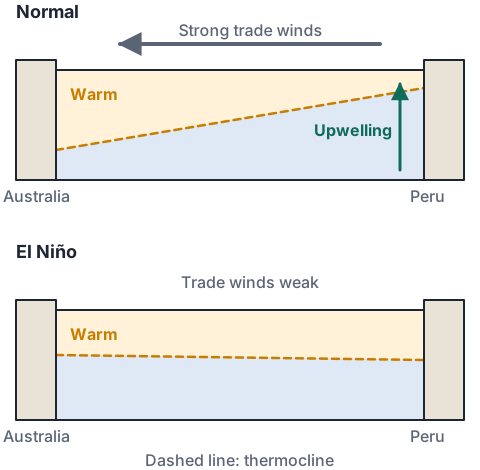
- Normally the south-east trade winds push warm surface water west across the equatorial Pacific, piling it up near Indonesia and Australia, where air rises and rain falls; the air returns east aloft and sinks over the cool eastern Pacific. This loop is the Walker circulation.
- With warm water pushed west, the thermocline is deep in the west and shallow in the east, so cold, nutrient-rich water upwells off Peru and Ecuador and supports huge fisheries.
- In an El Niño the trades weaken or reverse; warm water slides back east, the eastern thermocline deepens, upwelling stops bringing up nutrients, and the rising air and heavy rain move to the central and eastern Pacific.
- In a La Niña the trades are stronger than normal: more warm water piles up in the west, the east is colder than usual, and the western Pacific is wetter.
- The atmospheric half is the Southern Oscillation, measured by the Southern Oscillation Index (SOI) from air pressure at Tahiti minus Darwin: strongly negative in El Niño, positive in La Niña. Ocean and air feed back on each other, so the whole pattern is called ENSO.
| Event | Type | Peak Oceanic Niño Index (°C) |
|---|---|---|
| 1982 to 1983 | El Niño | +2.1 |
| 1988 to 1989 | La Niña | −1.8 |
| 1997 to 1998 | El Niño | +2.4 |
| 2010 to 2011 | La Niña | −1.6 |
| 2015 to 2016 | El Niño | +2.6 |
| 2023 to 2024 | El Niño | +2.0 |
What ENSO does to New Zealand
- El Niño: more south-westerly winds in summer and southerlies in winter, so New Zealand tends to be cooler; the West Coast of the South Island is wetter, while the north and east of both islands are drier, raising the risk of drought in places like Hawke's Bay, Canterbury and Marlborough.
- La Niña: more north-easterly winds, warmer seas and air around the country, and more rain in the north and east of the North Island, often from ex-tropical cyclones; the south and south-west of the South Island can be drier.
- ENSO shifts the odds rather than deciding the weather: NIWA estimates it explains less than a quarter of the year-to-year changes in New Zealand's seasonal rainfall and temperature, alongside the Southern Annular Mode and local weather.
- Fishers notice it too: warm La Niña seas bring subtropical fish south, while El Niño's cooler, windier conditions change where fish feed.
What Achieved, Merit and Excellence look like
- Excellence answers follow the chain of cause and effect all the way from the wind to the outcome, and say why for every link.
| Grade | A model answer |
|---|---|
| Achieved | In an El Niño, warm water moves east to Peru and there is less upwelling, so there are fewer nutrients and fewer fish. |
| Merit | Normally the trade winds push surface water west, so cold, nutrient-rich water upwells off Peru and phytoplankton grow. In an El Niño the trades weaken, warm water flows back east and the upwelling no longer brings nutrients to the surface, so plankton and the fish that eat them decline. |
| Excellence | When the trade winds weaken, the warm water piled up in the west flows back east and deepens the thermocline off Peru. Upwelling may continue, but it now lifts warm, nutrient-poor water from above the deepened thermocline, so nutrients no longer reach the sunlit layer. Phytoplankton production falls, anchovies starve or move, and catches collapse. The warm water also shifts rain and rising air east, which weakens the Walker circulation further: a feedback that keeps the El Niño going for months. |
Common mistakes
- Waves carry water across the ocean to the beach.Water particles move in circles and stay roughly in place; waves transfer energy.
- El Niño means the trade winds get stronger.The trades weaken in an El Niño; they strengthen in a La Niña.
- Doubling a wave's height doubles its energy.Energy is proportional to height squared, so doubling the height gives four times the energy.
- Spring tides happen only in spring.Spring tides come twice a month, at new and full Moon, when the Sun and Moon line up.
Model El Niño in a baking dish
You need: a clear rectangular baking dish, cold tap water, a cup of hot tap water, food colouring, a drinking straw, a spoon
- Fill the dish 3 cm deep with cold water and let it settle.
- Colour the hot tap water red and pour it slowly over the back of the spoon at one end, so a thin warm layer floats over the whole surface.
- Blow steadily along the surface through the straw from one end for a minute: this is the trade wind. Look from the side at both ends.
- Stop blowing and keep looking for another minute: this is the trades weakening.
- Look for: the warm red layer piles up thickly at the far end while clear cold water rises at the near end; when you stop, the warm water slides back, as in an El Niño.
Safety: Use hot water only from the tap and check it with your hand first, and only blow out through the straw.
Your turn
A swell has a period of 10 s in deep water. Find its speed.
Find its wavelength in deep water.
Find its speed in water 5.0 m deep.
A wave's height grows from 1.0 m to 2.0 m. By what factor does its energy increase?
High tide at Tauranga is at 3:40 am. About when is the next high tide?
During an El Niño, which way does warm surface water move, and what happens to upwelling off Peru?
Show answer
1. v = gT ÷ 2π = 9.8 × 10 ÷ 6.283 = 15.6 m s⁻¹. 2. λ = vT = 15.6 × 10 = 156 m. 3. v = √(9.8 × 5.0) = √49 = 7.0 m s⁻¹. 4. Energy ∝ height², so 2.0² ÷ 1.0² = 4 times. 5. Add about 12 h 25 min: about 4:05 pm. 6. It moves east, back across the Pacific, and upwelling of cold, nutrient-rich water off Peru weakens.
Exam-style question: El Niño and a Hawke's Bay farm
- NIWA has announced that an El Niño is developing. A Hawke's Bay sheep farmer wants to know what it might mean for the coming summer.
Describe what happens to the trade winds and the warm water of the equatorial Pacific during an El Niño.
Explain how these changes affect the Walker circulation and rainfall across the Pacific.
Explain why Hawke's Bay is more likely to be dry during an El Niño summer.
Explain why the farmer should treat the El Niño as a raised risk, not a certainty.
Show answer
1. The trade winds weaken or reverse, and the warm water piled up in the western Pacific spreads back east towards South America (Achieved). 2. With warm water in the central and eastern Pacific, rising air and heavy rain shift east, so Indonesia and northern Australia become drier and Peru wetter; the Walker loop weakens, which weakens the trades further, a positive feedback (Merit). 3. El Niño brings more frequent south-westerly winds over New Zealand. Air reaching Hawke's Bay from the south-west has crossed the ranges and dropped its moisture on the western side, then descends and warms on the eastern side (a rain shadow and föhn effect), so the east is drier and windier, increasing drought risk (Merit for wind direction linked to rain shadow). 4. ENSO explains less than a quarter of the variation in New Zealand's seasonal climate; the Southern Annular Mode, local weather systems and sea temperatures around New Zealand also matter, so some El Niño summers are not dry in Hawke's Bay (Excellence links the Pacific changes to New Zealand's winds and weighs the uncertainty).
Recap
- The ocean's large mass and heat capacity let it store and carry vast amounts of heat, which moderates coastal climates.
- Waves move energy, not water: v = gT ÷ 2π in deep water and √(gd) in shallow water; energy ∝ height².
- Tides come from the Moon and Sun; springs at new and full Moon, neaps at the quarters.
- El Niño: weaker trades, warm water east, less upwelling off Peru, more south-westerlies and a drier east in New Zealand. La Niña is the reverse.
| Formula | Use it for |
|---|---|
| Q = mcΔT | heat stored |
| v = gT ÷ 2π | deep-water wave speed |
| v = √(gd) | shallow-water wave speed |
| λ = vT | wavelength |
| E = ½ρgAh² | energy in a tidal basin |
Report a mistake
How is NCEA Level 3 maths going?
See the NCEA Level 3 maths guide