Atmospheric circulation: cells, wind belts and the westerlies
What this lesson covers
- Why uneven heating drives the atmosphere to carry heat towards the poles.
- The Hadley, Ferrel and polar cells, with their rising and sinking air and pressure belts.
- The trade winds, westerlies, polar easterlies and doldrums, and why each blows the way it does.
- The Coriolis effect, f = 2Ω sin φ, and how air turns around highs and lows in the Southern Hemisphere.
- New Zealand in the westerlies: moving highs and fronts, orographic rain, rain shadow and the föhn nor'wester.
- How the belts shift with the seasons and how that changes New Zealand's weather.
Uneven heating drives the winds
- Near the equator the Sun is high all year, so each square metre receives more energy than it radiates away; near the poles the reverse is true.
- Without a way to move heat, the tropics would keep warming and the poles cooling. The atmosphere and ocean carry the surplus polewards, and in the atmosphere this happens through convection: warm, less dense air rises, cool, dense air sinks.
- Rising air leaves low pressure at the surface and sinking air makes high pressure, and surface winds blow from high pressure towards low pressure.
- On a non-spinning Earth one huge cell in each hemisphere might do the job. Earth's rotation, through the Coriolis effect, deflects the moving air so much that the circulation breaks into three cells in each hemisphere.
The Hadley cell
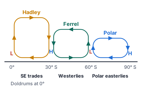
- At the equator strong heating makes moist air rise in towering thunderstorms. The rising air leaves low pressure at the surface along the intertropical convergence zone (ITCZ), with heavy rain and light, variable winds: the doldrums.
- The air spreads polewards near the tropopause, cools by radiating heat to space and is deflected by the Coriolis effect, so it piles up and sinks at about 30° N and 30° S.
- Sinking air is compressed and warms, so clouds evaporate: the subtropical high-pressure belt brings clear skies, which is why the great deserts, including central Australia's, lie near 30°.
- From the subtropical highs, surface air flows back towards the equatorial low, turned to the left by the Coriolis effect in the Southern Hemisphere: the south-east trade winds.
Try it: a convection cell
The polar and Ferrel cells
- Over Antarctica, very cold, dense air sinks and builds high pressure. It flows out towards about 60° S, turned to the left to become the polar easterlies.
- At about 60° S the cold polar air meets milder air flowing from the subtropics along the polar front. The milder air is forced up, giving the subpolar low-pressure belt, with frequent storms.
- Between 30° and 60° the Ferrel cell is driven by the two cells either side, like a gear: surface air flows polewards from the subtropical highs, and the Coriolis effect turns it towards the east, making the westerlies.
- The Ferrel cell is the least tidy of the three. In reality the mid-latitudes are full of moving highs, lows and fronts, which do much of the heat transport there.
The Coriolis effect and air around highs and lows
- Air moving across the spinning Earth is deflected to the left in the Southern Hemisphere and to the right in the Northern. The size of the effect is set by the Coriolis parameter, f = 2Ω sin φ, where Ω = 7.29 × 10⁻⁵ rad s⁻¹ is Earth's rotation rate and φ the latitude.
- f is zero at the equator, which is why tropical cyclones never form right on it, and largest at the poles; the sideways acceleration on moving air is f times its speed.
- Air starts to flow from high to low pressure, but the Coriolis effect keeps turning it until, above the friction of the ground, it blows almost parallel to the isobars.
- So in the Southern Hemisphere air circulates anticlockwise around a high and clockwise around a low. Near the surface, friction slows the wind, weakening the Coriolis effect, so the air spirals out of highs and into lows across the isobars.
Example: the Coriolis parameter over Wellington
- Find f at the equator, at Wellington (41° S) and at the South Pole, and the sideways acceleration of a 20 m s⁻¹ wind over Wellington.
- equator: f = 2 × 7.29 × 10⁻⁵ × sin 0° = 0
- 41° S: f = 2 × 7.29 × 10⁻⁵ × sin 41° = 1.458 × 10⁻⁴ × 0.656 = 9.57 × 10⁻⁵ s⁻¹
- pole: f = 1.458 × 10⁻⁴ × sin 90° = 1.46 × 10⁻⁴ s⁻¹
- acceleration = fv = 9.57 × 10⁻⁵ × 20 = 1.9 × 10⁻³ m s⁻²tiny, but it acts for hours over hundreds of kilometres
- 0; 9.57 × 10⁻⁵ s⁻¹; 1.46 × 10⁻⁴ s⁻¹; 1.9 × 10⁻³ m s⁻² to the left
The wind belts of the Southern Hemisphere
- Winds are named for the direction they blow from. Each surface belt runs from a high-pressure belt towards a low-pressure belt, turned left by the Coriolis effect.
- The belts in the Northern Hemisphere mirror these: north-east trades, south-westerlies and north-easterly polar winds.
| Belt | Latitude | Blows from | Weather |
|---|---|---|---|
| Doldrums (ITCZ) | 0° to 5° | Light and variable | Rising air, heavy showers |
| South-east trades | 5° to 30° S | South-east | Steady, mostly fine at sea |
| Subtropical highs | about 30° S | Light winds | Sinking air, dry and clear |
| Westerlies | 30° to 60° S | West (north-west to south-west) | Changeable: highs, lows and fronts |
| Polar easterlies | 60° to 90° S | East to south-east | Cold and dry |
Try it: name the wind belt
New Zealand in the westerlies
- New Zealand lies between about 34° S and 47° S, across the boundary of the subtropical highs and the westerlies, with the strong westerlies of the Roaring Forties to the south.
- High-pressure systems drift east across the country roughly every week, with troughs and cold fronts between them; a front usually brings a change from warm north-westerlies to cold south-westerlies.
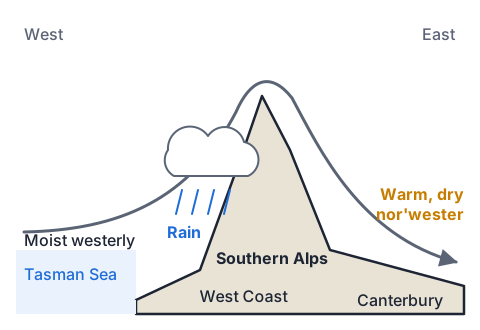
- The Southern Alps and the North Island ranges stand across the westerly flow. Moist air from the Tasman Sea is forced up, cools and drops heavy orographic rain on the west.
- Having lost its moisture, the air descends the eastern side, warming as it is compressed: the hot, dry, gusty föhn wind Canterbury calls a nor'wester. The east lies in a rain shadow.
| Place | Average yearly rainfall |
|---|---|
| Just west of the Southern Alps' main divide | over 10 000 mm |
| Milford Sound | about 6500 mm |
| Christchurch | about 620 mm |
| Alexandra, Central Otago | about 360 mm |
Example: the temperature of a nor'wester
- Air at 16 °C at sea level on the West Coast is forced over the Southern Alps, crest 2000 m. Cloud forms from 1000 m.
- Unsaturated air cools by 9.8 °C per km as it rises (and warms by the same as it sinks); cloudy, saturated air cools by about 6.0 °C per km, because condensation releases latent heat. Find the temperature when the air reaches sea level in Canterbury.
- 0 to 1000 m, dry: 16 − 9.8 × 1.0 = 6.2 °C
- 1000 to 2000 m, in cloud: 6.2 − 6.0 × 1.0 = 0.2 °Clatent heat slows the cooling; rain falls out on the west
- down 2000 m, dry: 0.2 + 9.8 × 2.0 = 19.8 °C
- 19.8 − 16 = 3.8 °C warmer than it started, and much drier
- about 19.8 °C in Canterbury
The belts shift with the seasons
- The whole pattern follows the Sun: in the southern summer the ITCZ and the subtropical high-pressure belt move south, and in winter they move north.
- In summer the subtropical highs often sit over or near northern New Zealand, giving long settled spells, while the westerlies are further south.
- In winter and spring the highs lie further north and the westerlies reach further up the country, so the weather is windier and more changeable, and the West Coast gets more rain.
- The Southern Annular Mode adds to this: when the westerlies contract towards Antarctica (positive phase) New Zealand tends to have lighter winds and settled weather; when they expand north (negative phase), it is windier, with more westerly rain.
What Achieved, Merit and Excellence look like
- Excellence links heating, convection, pressure, the Coriolis effect and the weather into one explanation.
| Grade | A model answer |
|---|---|
| Achieved | New Zealand is between 30° and 60° S, in the Ferrel cell, where the winds at the surface are westerlies. |
| Merit | Air sinks at about 30° S in the subtropical high and flows along the surface towards the subpolar low at 60° S. The Coriolis effect deflects it to the left in the Southern Hemisphere, so instead of blowing south it blows from the west. |
| Excellence | Strong heating at the equator makes air rise, flow polewards aloft and sink at about 30° S, building the subtropical high; cold air sinking over Antarctica rises again at about 60° S, giving the subpolar low. Between them, surface air flows polewards from high to low pressure, but the Coriolis effect, stronger at higher latitudes, turns it left until it blows from the west. With little land to slow them at these latitudes, the westerlies are strong, and New Zealand, at 34° to 47° S, sits in them, especially in winter when the belts shift north. |
Common mistakes
- The westerlies blow towards the west.Winds are named from where they come: westerlies blow from the west towards the east.
- In New Zealand air goes clockwise around a high.In the Southern Hemisphere air goes anticlockwise around a high and clockwise around a low.
- Air sinks at 30° because it has reached the edge of the cell.It sinks because it has cooled aloft and the Coriolis effect has turned it so it piles up and converges.
- The nor'wester is hot because it comes from Australia.It is warm because it dropped its moisture on the West Coast and was compressed and warmed as it descended.
Draw the Coriolis effect on a spinning plate
You need: a paper plate, a pencil, a ruler, a felt-tip pen, a helper
- Push the pencil through the centre of the plate so your helper can spin it slowly, like a turntable.
- With the plate still, draw a straight line with the felt-tip along the ruler from the centre to the edge.
- Now have your helper spin the plate slowly clockwise, as the Southern Hemisphere looks from above the South Pole, and draw along the ruler again from centre to edge at a steady speed.
- Compare the two lines.
- Look for: your pen moved in a straight line, but the line on the spinning plate curves to the left of the direction you drew, just as moving air curves left over the Southern Hemisphere.
Safety: Keep the pencil point away from faces and spin the plate slowly so it does not fly off.
Your turn
Find the Coriolis parameter f at 30° S.
Which wind belt is New Zealand in, and which direction does it blow from?
Which way does air circulate around a low in the Southern Hemisphere?
Air at 20 °C at sea level crosses a 1500 m range, with cloud forming from 500 m. Using 9.8 °C per km dry and 6.0 °C per km in cloud, find its temperature back at sea level on the other side.
Why are winds light in the doldrums?
Show answer
1. f = 2 × 7.29 × 10⁻⁵ × sin 30° = 2 × 7.29 × 10⁻⁵ × 0.5 = 7.29 × 10⁻⁵ s⁻¹. 2. The westerlies, blowing from the west (north-west to south-west). 3. Clockwise. 4. Up to 500 m: 20 − 9.8 × 0.5 = 15.1 °C; 500 to 1500 m in cloud: 15.1 − 6.0 = 9.1 °C; down 1500 m dry: 9.1 + 9.8 × 1.5 = 23.8 °C. 5. The air there is mostly rising, not moving sideways, and the Coriolis effect is almost zero, so there is little horizontal wind.
Exam-style question: deserts and trade winds
- Central Australia, at about 25° to 30° S, is one of the driest places on Earth, while northern Australia has a wet season of heavy tropical rain.
Describe where air rises and sinks in the Hadley cell.
Explain why the region near 30° S is so dry.
Explain why the surface trade winds in the Southern Hemisphere blow from the south-east.
Explain why northern New Zealand often has long settled spells in summer.
Show answer
1. Air rises at the equator (the ITCZ), flows polewards high up, and sinks at about 30° (Achieved). 2. The air that sinks at 30° has already lost its moisture as rain in the tropics; as it sinks it is compressed and warms, so its relative humidity falls, clouds evaporate and rain cannot form, giving the high-pressure subtropical desert belt (Merit). 3. At the surface, air flows from the subtropical high at 30° S back towards the equatorial low, so it starts moving north. The Coriolis effect deflects it to the left in the Southern Hemisphere, turning it towards the north-west, so it blows from the south-east (Merit). 4. In the southern summer the Sun is further south, so the whole circulation, including the subtropical high-pressure belt, shifts south. Large slow-moving anticyclones then often sit over northern New Zealand; their sinking air suppresses cloud and they block the westerly fronts, giving long dry, settled spells (Excellence links heating, cell structure, seasonal shift and the weather).
Recap
- Three cells in each hemisphere: Hadley (0° to 30°), Ferrel (30° to 60°), polar (60° to 90°).
- Rising air makes low pressure and rain (equator, 60°); sinking air makes high pressure and dry skies (30°, poles).
- The Coriolis effect, f = 2Ω sin φ, turns winds left in the Southern Hemisphere: south-east trades, westerlies, polar easterlies.
- New Zealand sits in the westerlies: weekly highs and fronts, rain on the West Coast, föhn nor'westers and rain shadow in the east.
| Latitude | Pressure | Surface wind |
|---|---|---|
| 0° | Low (ITCZ) | Doldrums |
| 0° to 30° S | Falls towards the equator | South-east trades |
| 30° S | High (subtropical) | Light |
| 30° to 60° S | Falls towards 60° S | Westerlies |
| 60° S | Low (subpolar) | Stormy |
| 60° to 90° S | High over Antarctica | Polar easterlies |
Report a mistake
How is NCEA Level 3 maths going?
See the NCEA Level 3 maths guide